 Walkably
Berlin and Munich: the districts that score best for walking
Neukölln has the highest Walkably score of Berlin's 97 districts (Ortsteile): 86.1 out of 100. The score combines how close daily needs are on foot with how pleasant the streets are. In Munich, Maxvorstadt leads the 25 districts (Stadtbezirke) with 84.8. The gap from first to last is wider in Berlin: 54.5 points, against 23.6 in Munich.
Published
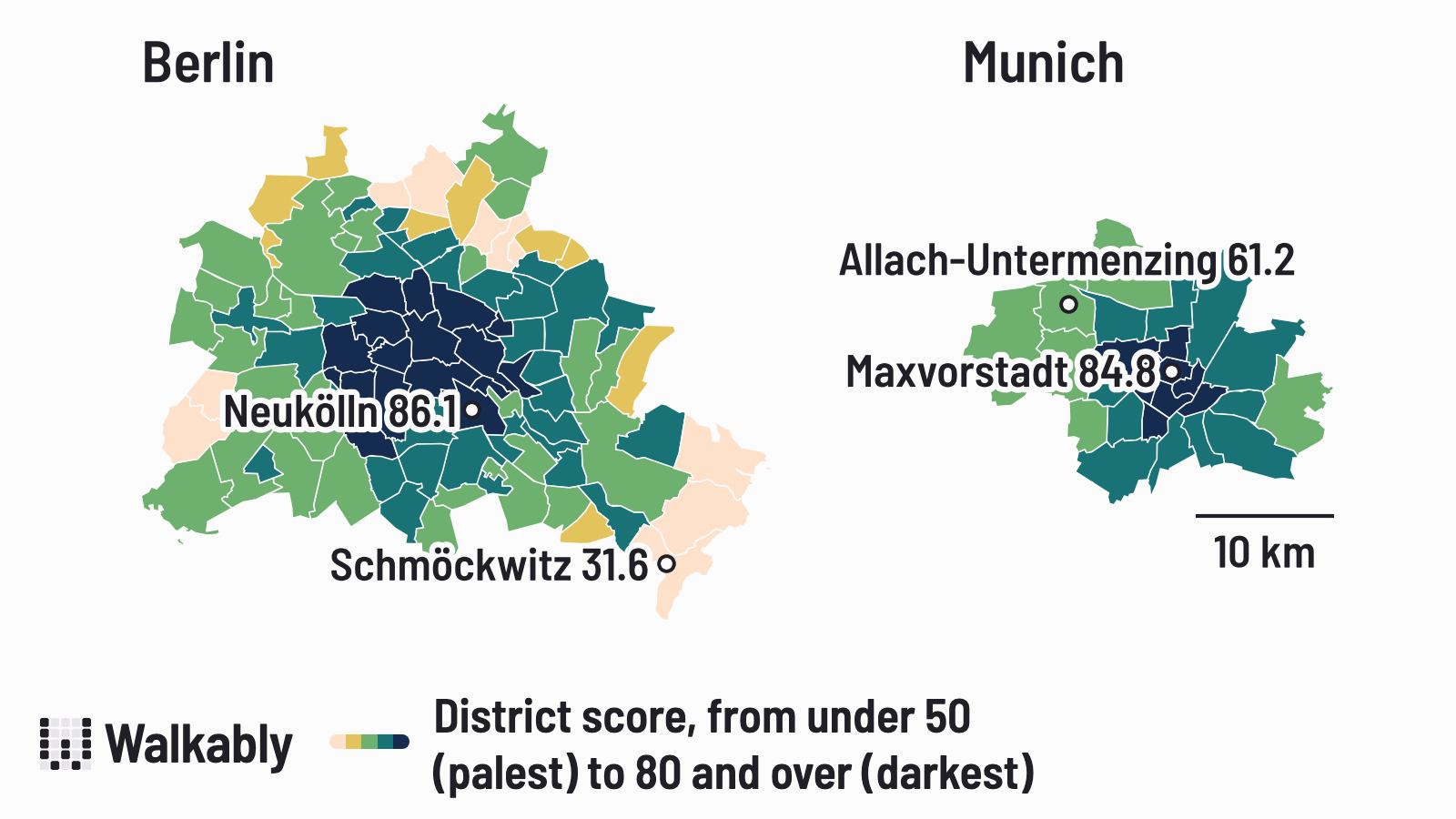
Berlin: Neukölln first, Schmöckwitz last
After Neukölln come Friedenau (85.4), Kreuzberg (85.3), Schöneberg (84.8) and Mitte (84.4). Schmöckwitz, at the south-east edge of the city, is last with 31.6.
In Berlin, 27% of residents have both a school and a park within 3 minutes on foot. The highest shares are in Fennpfuhl (54%), Gropiusstadt (52%) and Gesundbrunnen (45%). 22% have a grocery shop, a public transport stop and a health service all within 3 minutes, most often in Friedenau and Halensee (54% each) and Friedrichshain (46%).
The full table, with the walking minutes to each daily need, is on the Berlin district page.
Munich: a smaller gap
Maxvorstadt (84.8) is just ahead of Altstadt-Lehel (84.6) and Ludwigsvorstadt-Isarvorstadt (83.6). Au-Haidhausen, Schwabing-West and Schwanthalerhöhe share fourth place with 82.9. Allach-Untermenzing, in the north-west, is last with 61.2.
In Munich, 20% of residents have both a school and a park within 3 minutes on foot, most often in Au-Haidhausen (38%), Sendling (34%) and Schwanthalerhöhe (29%). The share with a grocery shop, a public transport stop and a health service all within 3 minutes is also 20%; it's highest in Altstadt-Lehel (54%), Schwabing-West (44%) and Ludwigsvorstadt-Isarvorstadt (42%).
All 25 districts are on the Munich district page. On both pages, you can type your own address and see which district it is in.
Close by, but not always pleasant
A short walk to everything doesn't mean the walk is pleasant. Around Checkpoint Charlie, on the line between Mitte and Kreuzberg, about 5,000 people live within 400 m. 96.7% of them have all eight daily needs we measure within 10 minutes on foot, against 59.8% in the rest of Berlin. But 71% of them live on streets whose quality is below that of a typical Berlin street. In the rest of the city, that share is one in two.
In Munich, about 2,500 people live within 300 m of the central part of Ludwigstraße. 79.7% of them have all eight needs within 10 minutes, against 54.0% in the rest of Munich. For 49% of them, at least half of the street length around their home is main roads, bus or tram routes, or roads with fast-moving traffic. In the rest of Munich the figure is 14.2%. Much of that difference comes from the roads with fast-moving traffic: counting only main roads and bus or tram routes gives 25.1% near Ludwigstraße and 11.4% in the rest of Munich.
Leopoldstraße, north of the Siegestor, shows the other side. 99.3% of the about 8,000 people within 300 m have all eight needs within 10 minutes, and only 18% live on streets below Munich's typical street quality. Around the central part of Ludwigstraße, that share is 54%.
How we measured
Walkably scores each city in small areas about 95 m across. An area's score, from 0 to 100, combines reach (60%) and street quality (40%). Reach is how far it is on foot to eight daily needs: groceries, food and drink, shops, health, school, parks, culture and public transport. Street quality looks at traffic, noise where an official noise map exists, summer shade (our estimate), main roads and slope. A street that is very unpleasant to walk lowers the score even more.
To score a district, we rank its residents from the lowest to the highest score of the area where they live, then take the score of the person in the middle: half of the district's residents live in areas that score higher, and half in areas that score lower. Resident numbers are estimates based on population data. The score uses nothing about who the residents are. The figures for Checkpoint Charlie, Ludwigstraße and Leopoldstraße count the people living within the given distance; the numbers of residents are rounded to the nearest 500. Map data from OpenStreetMap, 28 October 2026.
If you have questions, or want the figures for one district or street, write to us through our press page.
Data and sources
Walkably scores from OpenStreetMap data of 28 October 2026; district pages updated on 15 November 2026. How the score works.
Sources: