 Walkably
Walkability score for property listings in Europe
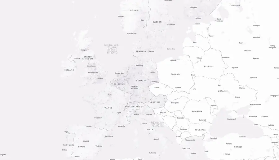
Your listing pages show rooms and prices, but they don't show the walk from the front door. Walkably gives property portals a 0 to 100 score for each address, plus walking minutes to eight daily needs. We measure minutes along real streets, not in a straight line. One method covers 31 European countries.
- 31European countries, one method
- Minutes on foot to 8 daily needs, on real streets
- A score for every six-sided area with sides of about 55 metres that has a street
- Census checks published, failures included
One real result, read from the live map
The product is live, and anyone can check single spots for free. Below is one location, read from the live map on 4 Oct 2026: Plaça d'Espanya in Barcelona.
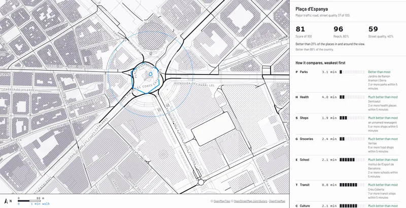
Score 81 of 100
Reach is 96 and street quality is 59. Reach measures walking minutes to eight daily needs and makes 60% of the score. Street quality is about the street itself (traffic, summer shade, slope) and makes the other 40%.
The eight walks, in minutes on foot
Food and drink 0.3, public transport 0.8, shops 1.9, culture 2.1, school 2.1, groceries 2.4, parks 3.1, health 4.0. Each number is the walk on real streets to the nearest place of that kind.
Two streets 150 metres apart
Along Plaça d'Espanya, a busy traffic road, street quality is 42 of 100. On Carrer de la Diputació, a car-free street, it is 88 of 100. The spot's own street quality is 59 and includes all the streets around it. The same shops are in reach, but the walk is very different.
Check your own listings
Search an address on the live map, or click any spot. Compare the score with a street your team knows. Hamburg has 93 of 104 official districts ranked on a map and in a sortable table. You can download a CSV spreadsheet file or put the table on your own page. The Hamburg ranking is in English and in German.
Why listings need more than the address
People who look for a home want to know if they can buy bread and reach a school on foot. A listing page shows rooms and price, not the walk.
Straight-line distance is not walking distance
At Plaça d'Espanya the Veritas supermarket is 70 metres away in a straight line. The walk takes 2.4 minutes. Walkably counts minutes on real streets, at 80 metres a minute.
Agent distance lists differ from listing to listing
When agents type their own lists, listings often use different sources and measures. A score built the same way for every listing replaces that.
One method across your countries
Portal groups list homes in several countries. A listing in Lisbon and a listing in Leipzig are scored with the same method, like every listing in our 31 countries.
Three places the score fits on a portal
Each use takes the same data.
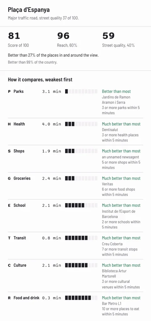
Listing page
Show the score next to the price. Under it, display minutes on foot to groceries, a school, a park, and public transport. Every listing uses the same method.
What you get: a listing page that says 2.4 minutes to groceries on real streets, instead of a straight-line distance.
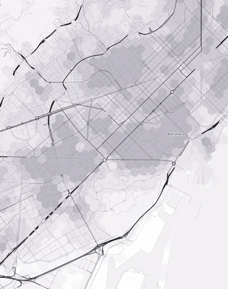
Search filter
Let visitors filter homes by score, or by minutes to one need. A family can ask for homes 10 minutes or less on foot from a school. A commuter can ask for homes 5 minutes or less on foot from public transport.
What you get: a filter on the question people ask: how far is it on foot.
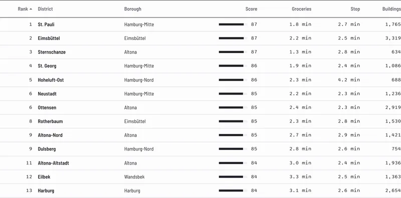
Area and neighbourhood pages
Give each city and district page a typical score and a rank in the country. Below the city score, show its areas best and least served by daily needs on foot. Our 477 public city pages show the pattern. The Hamburg district ranking shows a whole city: St. Pauli ranks first of 93 districts with 87.4. We make a ranking for your city on request; we confirm the date when you ask.
What you get: area pages where every statement about a neighbourhood has a figure behind it.
What you receive for each address
We score every six-sided area with sides of about 55 metres that has a street. Reach means the walking minutes to eight daily needs. The live map shows these fields for any spot. Which fields your files or API access carry is arranged with you.
| Field | What it holds | Part of the score |
|---|---|---|
| Walkability score | 0 to 100 for the spot | Reach 60% and street quality 40% |
| Walking minutes to each of 8 needs | Groceries, food and drink, shops, health, school, parks, culture, public transport. Minutes on real streets to the nearest place of each kind. | Reach |
| Street-quality parts | Traffic, noise where a city publishes noise maps, summer shade, busy roads and slope | Street quality |
| Example: Plaça d'Espanya, Barcelona (read 4 Oct 2026) | Score 81. Minutes: food and drink 0.3, public transport 0.8, shops 1.9, culture 2.1, school 2.1, groceries 2.4, parks 3.1, health 4.0 | Reach 96, street quality 59 |
If street quality is under 40, the score stays at 69 or lower.
Files for your addresses or areas
On request, send a list of the addresses of your listings, or the areas you cover. You receive the scores as files to load into your own system.
API access
API access means your software asks us for scores automatically as listings arrive. We arrange this per customer. The API page has the details.
Area and city reports, written for you on request
A report on one city or one area, written for you on request, with its typical score and the parts best and least served by daily needs on foot.
Custom rankings
We rank every district of a city, like the Hamburg page. We make these on request for the cities where you list; we confirm the date when you ask.
Updates and support
Updates to the scores and support are part of the service.
How we check the score
The method is public. We publish the checks, including the ones that failed.
How the score is built
Reach makes 60% of the score: walking minutes on real streets to eight daily needs. Street quality makes the other 40%: traffic, noise where a city publishes noise maps, summer shade, busy roads and slope. If street quality is under 40, the score stays at 69 or lower. So an apartment near many shops but on a busy road can score lower than one on a calm street.
Checked against census data
We compare the score with census data on walking to work, neighbourhood by neighbourhood. The result is a rank agreement from -1 to 1, where 1 means both lists put neighbourhoods in the same order. Before we saw any result, we set a pass mark of 0.35. France passed with 0.73. England and Wales reached 0.62, and Ireland reached 0.68. These checks cover France, England and Wales, and Ireland. For any other country, test your own listings on the live map first.
Failed checks are published too
Three checks failed, and we publish them on the About page next to the passes. The first is city-level walking shares from Eurostat, the statistics office of the European Union (-0.04). The second is summer shade (-0.18). The third tests the method in the ten largest US cities: it scored 0.34 against a pass mark of 0.35, a narrow fail.
Public method, open map data
The map is built from public data, mostly OpenStreetMap, a public map made by volunteers. Its licence, the ODbL, lets anyone use and share the map data with credit. Walkably is made by Raian Pollock.
How it compares with what portals use today
A portal has four ways to get location data. You can buy a ready-made score, or a scoring service you tune yourself. You can build from raw places and routing data, or take a free research map. The table compares them on facts you can check on each vendor's own page. Every row was read on 14 Oct 2026; the sources are on a separate page, 'How we compared', linked right under the table.
| Option | Europe coverage | What you get | Method and checks public | How you buy, and the licence |
|---|---|---|---|---|
| Walkably | 31 European countries, every six-sided 55 m area with a street | Score 0 to 100, minutes to 8 needs, street-quality parts | Method on the About page; census checks published, passes and failures | No public price list; files, reports and API access arranged per customer. Scores under the ODbL: credit OpenStreetMap; a changed version that is shared stays under the ODbL |
| Walk Score | Officially supports the US and Canada; its public site shows scores marked 'Unsupported Country' for some European streets | Walk, Transit and Bike scores | Method on its site; it says academic researchers validated it, with a research page; independent studies in US cities; none found for Europe | Free plan for free consumer apps; Premium from $115 a month, quoted per site; display only on a freely accessible site the licensee owns |
| Local Logic | Every address in the US and Canada, per its pages | 18 location scores, 36 categories of places | Not described on locallogic.co or docs.locallogic.co | API from $1,500 a month |
| PriceHubble location scores | Its location-score documentation lists Austria, Belgium, Switzerland, Czechia, Germany, France, the Netherlands, Slovakia, the UK and Japan | Catering, family, health, leisure and shopping scores; a noise score | Method not explained on that documentation page | API; no price shown on its documentation pages |
| Targomo Location Scoring | Its pages say 25+ and 30+ countries worldwide; it does not list them | Travel times and raw scores on criteria you choose; pre-built ratings on request | You set the criteria, so there is no single score to check | Location Scoring API: EUR 2.00 per 1,000 requests (Targomo calls them operations), down to EUR 1.00 at 1 to 2 million; EUR 300 free a month for public, free apps; private use quoted. Travel-time APIs are priced separately |
| Google Places API | Not stated per country | Raw place search and route times; no walkability score | No score to check | Nearby Search Pro: $32 per 1,000 calls at the first paid tier (5,001 to 100,000 a month), $9.60 at 1 to 5 million. If each need is one call, 8 calls an address is about $0.08 at the high-volume tier, before routing. European Economic Area terms: coordinates may be kept 30 days at most; most other results only for the listed permitted uses and not shown on a map; general terms also bar creating content from Google content |
| Mapbox walking-time areas (Isochrone API) | Not stated per country | Walking-time areas up to 60 minutes; no score | No score to check | Free to 100,000 requests a month, then $2.00 per 1,000, down to $1.20 at 1 to 5 million; you may not pass the data on to others; real-estate applications need a separate commercial licence for production use |
| 15-Minute City Score Europe Map (Transform Transport) | 786 urban areas above 50,000 inhabitants | 0 to 100 per six-sided area of about 0.105 km2, 8 service categories, OpenStreetMap of 30 April 2025 | Method on its page; no validation described | Free download; licence CC BY-NC-SA 4.0 on its Zenodo record: non-commercial use only |
| Build it yourself from OpenStreetMap | All of Europe: a 32.8 GB extract under the ODbL | Whatever you build: free routing software (OSRM, Valhalla), your own categories and weights | Yours to publish. A 2021 study of shops in two German states found completeness from 42% to 100% by district; the mean was high | Software is free; the cost is your own engineering time. ODbL: credit OpenStreetMap; a changed database that is shared stays under the same licence |
Facts were read on the vendors' pages and the cited sources on 14 Oct 2026. Prices are in the vendor's currency and tier as published that day. The Walk Score research page lists the studies it cites. The 15-Minute City Score licence is stated on its Zenodo record, not on the Transform Transport page.
Coverage in Spain, Italy, Poland and the Nordics
Of the ready-made scores in the table, Walk Score and Local Logic officially support the US and Canada, per their own pages. PriceHubble's location-score documentation lists nine European countries. Targomo returns raw scores on criteria you choose and doesn't list its countries. Ask it directly. On 14 Oct 2026, we found no ready-made score covering Spain, Italy, Poland, or the Nordics. Walkably covers 31 European countries with one method.
If you want to check the method
Walk Score, Walkably and the 15-Minute City Score describe their method. Local Logic's pages and PriceHubble's documentation page do not (checked 14 Oct 2026). Only Walkably publishes all seven of its checks against census data and other sources, including the three that failed.
Where Walkably is weaker
We don't publish a price list or offer self-serve sign-up. You write to us, and we arrange access per customer. Walk Score, Local Logic, Targomo, Google and Mapbox publish prices. Our census checks cover three countries: France, England and Wales, and Ireland. Like every option built on OpenStreetMap, Walkably depends on how well an area is mapped.
Questions property portals ask
What product and data teams ask before they write to us.
Which countries do you cover, and is the method the same in each?
Walkably covers 31 European countries. You'll find the full list just below. We score every six-sided area with sides of about 55 metres that has a street. The method is the same everywhere. Our census checks cover France, England and Wales, and Ireland. For any other country, test your own listings on the live map first.
- Andorra
- Austria
- Belgium
- Bulgaria
- Croatia
- Cyprus
- Czechia
- Denmark
- Estonia
- Finland
- France
- Germany
- Greece
- Hungary
- Iceland
- Ireland
- Italy
- Latvia
- Liechtenstein
- Lithuania
- Luxembourg
- the Netherlands
- Norway
- Poland
- Portugal
- Slovakia
- Slovenia
- Spain
- Sweden
- Switzerland
- the United Kingdom
Should we take files or API access?
It depends on how listings reach you. A fixed list of listings is simpler as files, which you load into your own system. Listings that arrive all day fit API access better, where your software asks us for scores automatically. We arrange that per customer. The API page explains the details.
We already pay for a routing or travel-time service. What's different?
A routing service returns travel times between the points you give it. Walkably returns a score from 0 to 100 with its parts: minutes to eight daily needs and street quality. It uses one method for every listing in 31 countries. The two answer different questions.
How do you know the scores are right when OpenStreetMap has gaps?
We compare the scores with census data on walking to work, neighbourhood by neighbourhood. France, England and Wales, and Ireland reached a minimum score that we chose before we saw any result. Three checks failed. They're published on the same page. OpenStreetMap is less complete in some areas, which applies to us as to anyone building on it. Check a few of your own listings on the live map and compare the score with the street you know.
Can we store and show the scores, and what does the open licence mean?
The scores form a database built from OpenStreetMap, so they fall under the same open database licence, the ODbL. You can use, store, change and share them, also commercially. Two rules apply. You credit OpenStreetMap with this line: Contains information from OpenStreetMap, © OpenStreetMap contributors, available under the ODbL. If you share a changed version of the database, you share it under the ODbL too. The full licence text is public at opendatacommons.org, so your legal team can read it. Tell us how you plan to use the scores when you write.
How often are the scores updated?
Updates to the scores are part of the service, together with support.
How is it priced?
We don't publish prices. The price follows your number of listings and the format you choose. Write to [email protected] with your countries and about how many listings you have. Single checks on the live map stay free for anyone.
Coming soon
- District rankings like Hamburg's for more cities.
- City pages in more local languages.
- A population and age layer.
- More countries beyond our current 31.
Send your countries and listing count
One email starts it. Tell us which countries you list in and about how many listings you have. Say whether you prefer files or API access.
[email protected]Email [email protected]
Use the subject line "Walkability scores for our listings - [portal], [countries]". The link opens an email with three lines to fill in: countries, number of listings, files or API access.
What happens next
We answer with how we can deliver for your countries and your number of listings, as files or as API access. Then we score your addresses or areas with the same method as the live map, in any of the 31 countries. Updates and support follow.
Or check one spot first
The live map is free for single checks. Search a listing your team knows and compare the score with the street.
Other pages for companies
Read the business overview at /business/, the API page at /business/api/, and the pages for property developers, consultancies and cities.